Irish Independent – WALK OF THE WEEK – Christopher Somerville
4 July 2009
17. Glenariff, Co. Antrim
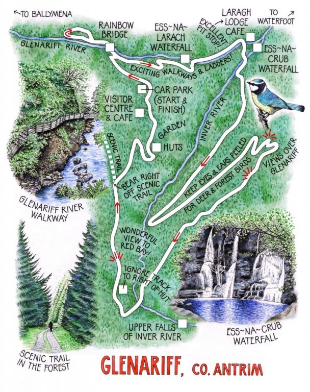
 Glenariff, ‘Queen of the Antrim Glens’, lay stroked by early mist. From the high perch of Glenariff Forest Park, the views that Jane and I had of the upthrust cliffs of the glen seemed softened and toned down. But as the summer morning broadened and the sun came through, the hard purple and slate hues of the naked rock reinstated themselves.
The nine Glens of Antrim are harsh country. Glenariff, largest and deepest of all, is no exception. Like its neighbouring clefts, bleak moorland tops Glenariff. Ancient woodland clothes its flanks, and rivers and springs cut down through the basalt that formed it some 60 million years ago, the seaward pouring of a gigantic outflow of lava. Ice Age glaciers gouged Glenariff deep and narrow, and tumbling waterfalls and cataracts continue the scouring process today. Four Forest Trails show walkers a number of aspects of Glenariff, and this morning Jane and I were aiming to link up the longer of the walks, the Waterfall Walk and the Scenic Trail, to taste the cream of this superb landscape.
Blue tits gave out a thin, clockwork pzzit! pzzit! and chaffinches their explosive run-and-hurl-the-ball songs as we descended the path towards the Glenariff River, whose faint roar came up from far below. Down there in the leafy half-light we crossed Rainbow Bridge to explore the damp cleft beyond, every crevice packed and dripping with luxuriant moss cushions, jointed horsetails and creamy fungi sucking moisture from rotting logs. ‘Bryophytes,’ murmured Jane the botany graduate, parting the mosses round a sodden tree stump to reveal fleshy, dark green leaves like a miniature tropical forest. ‘They need a lot of water …’
The Waterfall Walk led us down wooden stairs and along teetery walkways, winding deeper into the gorge cut by the Glenariff River. At one moment the path ran beside the river; the next it had leaped 50 feet above it and was catwalking along the wall of the cleft. Zigzagging back down, we crossed a bridge and turned to enjoy a spectacular sight: the double cascade of Ess-na-Larach, the Mare’s Fall, tumbling like a swishing horse’s tail 50 feet into a smoking pool, then sluicing over rocks almost as far again to hiss into the bed of the gorge.
Just above the confluence of the Glenariff and Inver Rivers is the second of the glen’s breathtaking waterfalls, Ess-na-Crub, the Fall of the Hooves – another equine inspiration, perhaps drawn from the thunderous noise of the water. We drank a cup of tea in the Laragh Lodge café, looking out through the trees towards Ess-na-Crub. ‘The thing I like about that view,’ said the owner, peering out and grinning as though savouring it for the first time, ‘is it changes all the time. In a few months those leaves will be on fire; then they’ll drop and we’ll be able to see the fall properly; and then the snow will be down and it’ll be different again.’
We turned aside to see the Fall of the Hooves at close quarters, and then commenced a long back-and-forth climb through the forest to the lip of the glen. Up there the moorland lay silent under strong sunlight. The upper falls of the Inver River came crashing over a basalt lip high on the skyline. Turning down the homeward path we saw the whole of Glenariff stretched out ahead, purple cliffs on high, wooded slopes sweeping down to a far-off glimpse of the sea in Red Bay, where a solitary fishing boat rocked at ease in the hazy summer afternoon.
WAY TO GO
MAP: OS of Northern Ireland 1:50,000 Discoverer 9; downloadable map/instructions at www.walkni.com, and www.forestserviceni.gov.uk.
TRAVEL:
Bus (www.nirailways.co.uk): Ulsterbus Service 150 (Ballymena-Cushendun) stops at Glenariff Forest Park.
Road: From A2 coast road at Waterfoot, A43 Ballymena road passes Glenariff Forest Park.
WALK DIRECTIONS: From Glenariff Forest Park car park, follow Waterfall Walk/WW signs. At foot of slope, by WW signboard, bear left down path to cross Rainbow Bridge. Track soon doubles back to re-cross bridge and continue along WW. Follow WW to Laragh Lodge tea room.
Cross Glenariff River and start up track; detour left to see Ess-na-Crub Waterfall; then on up track. In 100 m fork left to cross Inver River, following Scenic Trail/ST upwards through zigzags and up steps and slopes for 2½ miles to cross upper waters of Inver River. A few 100 metres further on, track marked by signboard branches sharply right past hut; ignore this, and continue for ½ mile to where ST crosses downward-sloping track opposite old quarry hopper. Bear right off ST down track; right by building at bottom to reach wooden huts in gardens. Steps behind huts lead up into gardens; bear right (‘Viewpoint Walk’) to car park.
LENGTH: 5 miles: allow 2½-3 hours
GRADE: Moderate
CONDITIONS: Many steps; some steep slopes; paths can be slippery
DON’T MISS … !
• Ess-na-Larach Waterfall on Glenariff River
• Ess-na-Crub Waterfall on Inver River
• spectacular falls to left as you cross upper Inver River
• views on way back, down Glenariff to sea
REFRESHMENTS: Glenariff Forest Park Café; Laragh Lodge Restaurant (028-2175-8221)
ACCOMMODATION: Dieskirt Farm, 104 Glen Road, Glenariff, Co Antrim BT44 0RG (028-2177-1308; www.dieskirtfarm.co.uk) – from £50/€57
www.christophersomerville.co.uk