 Irish Independent Walk of the Week Christopher Somerville
5th February 2011
85. Claragh Mountain, Millstreet, Co. Cork
Millstreet sits at the feet of the mountains where the Boggeragh and Derrynasaggart ranges come together in the tumbled country of north Cork. It’s a neat, compact place with brightly coloured houses along the main street, some handsome neoclassical public buildings and a cheerful air of civic pride. Just the place to host a superb walking festival – and that’s an ever-growing twinkle in the eye of Derry Sheehan, Michael Thornton and such hometown brethren as enjoy getting out and about in their native hills and countryside.
Today a stormy morning of scudding cloud and spitting rain had settled over the town and its attendant mountains. But what’s that to a pair of walkers as enthusiastic as Derry and Michael? Well wrapped in raingear glazed and glistening with rainwater, the three of us headed out of town towards the shapely bulk of Claragh, Millstreet’s guardian mountain.
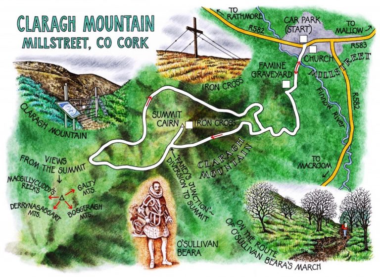
Beside the road a modest iron gateway opened onto a quiet walled field sloping towards the town. Parallel rows of green hummocks striped the ground, looking at first glance like ancient grassed-over potato ridges. A sad irony. The rainy field was a cillín, resting place of famine dead, each victim commemorated by a simple uncarved boulder.
A leaf-strewn track running with water took us up through woodland of silver birch and spruce to a stile out onto the open mountainside. Claragh stood ahead, a double hump scabbed with rock outcrops, the rich gold of its bracken leached out to milky yellow in the moisture-laden air. Dark sandstone veined with columnar shards of quartz crunched and wobbled under our boots as we followed the path up and along the flank of Claragh.
Walking in the wet is all about perspective. Once you’ve reeled in your expectations and decided to view your surroundings through the eyes of a fish – a lungfish, maybe – there’s a pleasure in picking out the faintly looming whalebacks of great hills, and making a resolution to come back and walk them in glorious sunshine one day.
A side track took the three of us up the nape of Claragh to the big iron cross that parishioners erected near the summit some 30 years ago. Up there, standing straddle-legged against a wind strong enough to have us staggering, I took in the strange subaqueous lift and roll of the Derrynasaggart Mountains. The rugged crowns of Macgillycuddy’s Reeks stood beyond, way down west in Kerry, while to the north-east rose the shapely profile of the Galtees over the Tipperary border. So Derry and Michael informed me; but for all I could see of them, they might as easily have been the mountains of the moon.
The wind thrummed in the bracing wires of the rusty old cross, driving us off the hilltop. It whistled through the stones of the summit cairn whose neat pyramid hides the bones of a buried priest. We hightailed it down into the shelter of the flank, and followed a clear track through the heather to join the eastward-coursing Duhallow Way.
The cobbled old path led down between the mossy walls of animal pens long gone to ruin. Did O’Sullivan Beara and his brave tatterdemalion force huddle along this track on a bleak January day in 1603 on their epic 200-mile midwinter march to Leitrim? It seems more than likely. Nowadays a fine new route for walkers and cyclists, the Beara Breifni Way, traces O’Sullivan Beara’s extraordinary trek. The fugitives set out from the Beara peninsula of West Kerry a thousand strong; they reached Leitrim a fortnight later numbering fewer than forty survivors, reduced by starvation, exhaustion, desertion and the constant attacks of enemies.
Humbled by the tale, we shook off the raindrops and followed the ancient way thoughtfully back to Millstreet.
WAY TO GO
MAP: OS of Ireland 1:50,000 Discovery 79; downloadable map/instructions at discoverireland.ie/walking
TRAVEL:
Rail (irishrail.ie) to Millstreet
Bus (buseireann.ie) 257 (Killarney-Macroom)
Road: N72, R583 from Dromagh; or N22, R582 from Macroom. From Millstreet follow R582 (‘Rathmore’) to outskirts of town. Car park on right opposite church.
WALK DIRECTIONS: Cross R582; follow L1130 to right of church. Ahead at junction (‘Claragh Loop Outward’). In 250 m pass Marian shrine (Famine graveyard/cillín is 100 yd further on right). Just past Marian shrine, turn left up path (purple arrow/PA); in 500 m, right (PA) up forest track. In 600 m, left over stile (PA) along flank of Claragh Mountain, following ‘Claragh Outward’ signs. In 1.1 km, detour to right at ‘Fahey’s Junction’ to top of mountain and back (white arrows; 20-30 mins return). 100 yards past junction, left over stile (PA); downhill along fence, following ridge path + PAs for 1.2 km down to hairpin right along Duhallow Way (yellow walking men/YM Symbols). Follow PA and YM back along north flank of Claragh Mountain, up through woods, down to rejoin outward path, back to Millstreet.
LENGTH: 6½ miles/10 km: allow 3 – 3½ hours
GRADE: Moderate
CONDITIONS: Country roads, forest tracks, muddy mountain paths.
Don’t Miss…!
• Cillín/famine graveyard
• View from summit of Claragh Mountain
• Mossy remains of settlement on homeward path
REFRESHMENTS/ACCOMMODATION: Wallis Arms, Millstreet (029-71445; wallisarms.com)
BEARA BREIFNI GREENWAY: bbgreenway.org
MILLSTREET WALKING FESTIVAL (coming soon): phone Derry Sheehan 086-266-5893
WALKING IN IRELAND: Walking tour operators, local walks including Discover Ireland’s National Loop Walks, walking festivals throughout Ireland: www.discoverireland.ie/walking.
INFORMATION:
Mallow Tourist Office: Bridge Street (022-42222); http://www.discoverireland.ie/Destinations/Cork.aspx
http://www.discoverireland.ie/Activities-Adventure/claragh-loop/80893