Irish Independent Walk of the Week Christopher Somerville
23 April 2011
No 93: Lough Muskry, Galty Mountains, Co. Tipperary

It’s not often that Jane and I have the pleasure of going walking with my sister Lou. Living in London, as she does and we don’t, our paths cross far too seldom for my liking. So the call of a walking weekend together in the Glen of Aherlow proved irresistible. A couple of nights in one of the lodges at the walker-friendly Aherlow House Hotel, a bit of info exchange and a lot of laughing sounded just the ticket. As for the walking – with the delectable Galty Mountains literally (well, almost) on the doorstep, there’d be no shortage of that. The only question mark was against the elements. Would it be rain or shine over the Galtees? And when the Clerk of the Weather decreed a perfect blue-sky spell for County Tipperary, that was nicely sorted too.
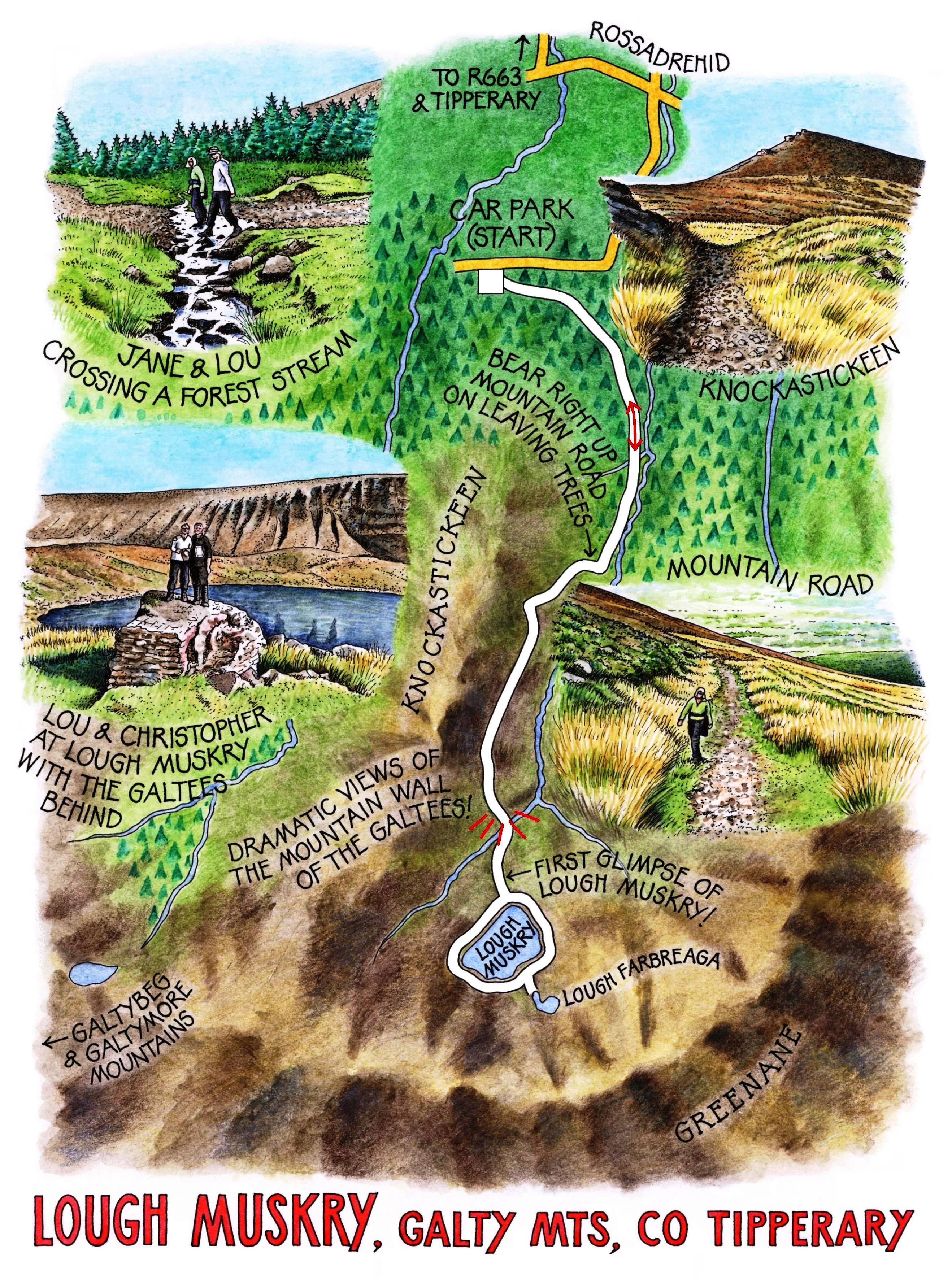
We did several memorable walks from Aherlow House over the weekend, and one of the peachiest was an afternoon expedition to Lough Muskry, one of a string of little mountain lakes lying in the shadow of the Galtees’ dramatic northern face. The Muskry walk is one of the best known in the Glen of Aherlow, for a good reason: it’s an absolute beauty, with mountain views which improve with every step, and the prize at the end of the upward path, the lough itself, lying hidden until you are right beside it. Lou is a mighty walker with some remarkable treks all over the world under her belt, but I knew she wouldn’t turn up her nose at this little Galty gem.
The three of us set out from the car park above Rossadrehid on a wide track of crunchy stones that took us steadily up through forestry. Between the spruces and pines there were tantalising glimpses of the mountains ahead, a warm misty blue, Galtymore’s double peak as a solid summit from which Galtybeg and the lower ridge bumps ran out in our direction. A pair of ravens cronked to each other in the treetops, a sound like coarse bar-room laughter – scarcely distinguishable, truth be told, from our own guffawing as we relived last night’s craic.
Where the trees came to an end, the second phase of the climb began, up a steep old mountain road in the flanks of Knockastickeen. Winter floods and generations of pounding boots had reduced the track to a trough of stumbly pebbles like a dry riverbed, but soon we were at the top of the rise and looking down. Not at Lough Muskry, however: not yet. The corrie lake, formed in a hollow gouged out under Greenane mountain by glaciers during the last Ice Age, lies concealed behind a final hump of ground, a moraine of ice-tumbled boulders. Once we’d surmounted that, Muskry slipped modestly into view, a wind-ridged diamond of deep dark water, half black with mountain shadow, half brilliant blue with reflected sky, cradled in a scoop of the mountain wall behind.
A lake so secret, in such a wonderful location, is bound to have a tale or two immersed in it. One hundred and fifty maidens live in Lough Muskry, so legend says. Every couple of years they take wing as birds, and one of their number is transformed into the most beautiful bird in the world, distinguished by a gold necklace and a jewel as rare and sparkling as Lough Muskry itself.
There was no sign of the hundred and fifty maidens today, and with the sun slipping towards the uplifted ridge of the Galtees there was no time to wait and see if they’d return as birds. Quite frankly, we had better things to do. Jane went botanising along the shore, Lou set out to explore the upper slopes towards Muskry’s hidden sister lough of Farbreaga, and I made a quick slip-and-slide circuit of the lake under the striated cliffs of Greenane, stumbling on stones and sliding on peat hags. Then it was back along the stony road below Knockastickeen, down towards the Glen of Aherlow through gorse thickets ringing with birdsong – the Muskry maidens at their vespers, we decided.
WAY TO GO
Map: OS of Ireland Explorer 74; walk pamphlet with map available at Aherlow House Hotel (see below)
TRAVEL: M8 (Jct 9), N74 to Tipperary, R664 to Glen of Aherlow. Left on R663, next right (country lane) to T-junction, left to Rossadrehid. Opposite post office, right (‘Lough Muskry’) up lane. Round sharp right bend; on for ½ mile to car park on left.
WALK: From car park follow green ‘walking men’ signs and arrows up stony road on left for 1½ miles (2.5 km), to gate at end of forestry. Right here up stony mountain road to Lough Muskry. Walk circuit of the lough. To reach Lough Farbreaga, continue uphill past left (east) side of Lough Muskry.
Retrace route to car park.
LENGTH: 6 miles (10 km) – allow 4 hours (take your time!)
CONDITIONS: Forestry track; stony, rubbly mountain road. NB walk round Lough Muskry is slippery in places
REFRESHMENTS: Picnic
DON’T MISS …
• views back from mountain road
• circuit of Lough Muskry
• Lough Farbreaga, just above Lough Muskry
ACCOMMODATION: Aherlow House Hotel, Glen of Aherlow, Tipperary (062-56153; aherlowhouse.ie) – very welcoming, comfortable and walker-friendly.
WALKING in IRELAND: Walking tour operators, local walks including Discover Ireland’s National Loop Walks, walking festivals throughout Ireland: www.discoverireland.ie/walking.
GLEN OF AHERLOW SUMMER WALKING FESTIVAL: 3-6 June 2011 (062-56331; aherlow.com)
Tinahely Trailwalking Festival, Co. Wicklow: 29 April-2 May (www.tinahely.ie)
Donegal Bluestack Walking Festival: 30th April-1 May (087-784-4803;
www.donegalwalkerswelcome.com)
Barrow Way Challenge Walk: Robertstown-St Mullins (70 miles), Friday 6-Sunday 8 May – info 087-220-6360; mgrainger@mobileemail.vodafone.ie
INFORMATION: Glen of Aherlow Fáilte Society (062-56331; aherlow.com)
csomerville@independent.ie