Irish Independent – WALK OF THE WEEK – Christopher Somerville
11 September 2010
74. Mulranny and Lookout Hill, Co. Mayo

The little town on the way to Achill Island is so good they named it thrice (at least) – Mulranny, Mallaranny and An Mhala Raithní, the ‘ferny hilltop’. Whatever about the name (and the Irish is pretty accurate – the place lies below bracken-covered hills), I only knew Mulranny as the place you passed on your way from Westport to Achill Island. I must have driven through the town a dozen times with bleary eyes and beery head on the morning after a late-night session in Hoban’s or McHale’s, looking forward to a life-saving blast of Achill’s salty winds. But I’d never stopped and strolled about Mulranny until Tom Carolan, County Mayo’s Rural Recreation Officer, invited Jane and me out there to do just that.
We set off five strong from the strand car park below the town. Tom had whipped in another of the Carolan clan, local farmer and keen walker Seán; and also along for the stride was Trinity sociology student Yoshi, all the way from Kyoto and very enthusiastic about the new walking trails that are springing up all across Ireland. The loop we were following today was so new it didn’t even have a name, so untrodden that at times we found ourselves breaking virgin ground on the hillsides. It’s also one of the most beautiful short walks in this island.
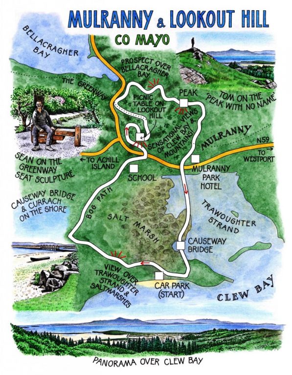
From a boreen we looked back across Trawoughter Strand, the delicate cast-iron causeway bridge that spans it, and the wide saltmarshes that form a larder for geese in winter and wading birds all year round. Today the marshes lay flushed with the rich pink of uncounted millions of sea thrift flowers, all open under the blue Mayo sky.
That was some view; but there was a better one from the picnic table on top of Lookout Hill, a superb panorama across Clew Bay, from the long whalebacks of the Nephin Beg range back east to the bulgy spine of the Mweelrea mountains down in the south-west on the doorstep of Connemara. South across the bay rose the centrepiece of this classic prospect of sea and hills, Croagh Patrick itself, with the profile of a lion, head on paws. The flat table tops of the Sheefry Hills and the long back of the Renvyle peninsula completed the vista, with a hint of Inishbofin at the corner of sight, far out on the glittering sea.
You don’t want to hurry away from a view like that, and we didn’t. But at last we moved on, down through patches of sphagnum-squelching native heath – ‘Very rare, and only thrives here because of the Mediterranean climate of Mulranny,’ winked Seán.
At the foot of the hill ran the Greenway, a cycle track developed along the line of the old Westport-Achill railway that’s rapidly becoming the spine of a whole network of footpaths in this lovely and eminently walkable part of the world. We passed a bronze sculpture of a seat fashioned out of old suitcases – a poignant reminder of hard times past, when Achill men would leave their families and ride the trains and boats to the seasonal potato harvests of far-off Scotland.
From the Greenway the path led up through rocky stands of ash and pine, out to a sensational view west over Bellacragher Bay under its mountain slopes, a steely blue comma at the south-east toe tip of Blacksod Bay. Steeply up through the heather to a peak with no name for a last long look at that sensational prospect over Clew Bay; a descent to a welcome cup of tea on the sunny terrace of the Mulranny Park Hotel; and a final stretch by way of the causeway bridge across the lagoons of Trawoughter Strand, where jellyfish with neon purple rings drifted gracefully in the incoming tide.
WAY TO GO
MAP: OS of Ireland 1:50,000 Discovery 30; downloadable map/instructions (highly recommended) at discoverireland.ie/walking.
TRAVEL:
Rail (irishrail.ie): Westport (17 miles)
Bus (buseireann.ie): 440/441 (Westport-Achill)
Road: N59 from Westport to Mulranny. Left at church (L1404); follow ‘Beach/Trá’ to seafront car park.
WALK DIRECTIONS: Return along road. At right bend, keep ahead up boreen (red arrow/RA). Left at the fork. Cross road; on up lane; in 200m, right on bog path. Left at road; right to pass in front of school; cross N59 (take care!); through wall gap. Climb path through rhododendron wood. Left at track (RA) up Lookout Hill to summit picnic table. Continue, following RAs down through forest to Greenway. Left along Greenway, forking right immediately; in 250m, right down steps (RA) to road. Left to corner; right by ‘Mallaranny’ sign, up through trees to top of rocky knoll. Follow RAs down through rhododendron and bog to road. Ahead to Mulranny Park Hotel. Down front steps; cross roadway (‘footpath to beach’), down more steps; left, and follow red arrows to iron bridge and car park.
LENGTH: 3½ miles: allow 2 hours
GRADE: Moderate/Hard
CONDITIONS: Tracks, bog and woodland paths; a couple of short steep climbs.
DON’T MISS … !
• view from boreen over Mulranny Strand and bridge
• bronze suitcase/bench sculpture on the Greenway
• view over Clew Bay from the highest knoll
REFRESHMENTS/ ACCOMMODATION: Mulranny Park Hotel (098-36000; mulrannyparkhotel.ie)
WALKING in IRELAND: Walking tour operators, local walks including Discover Ireland’s National Loop Walks, walking festivals throughout Ireland: discoverireland.ie/walking.
Mulranny Experience walking/cycling weekend, 17-19 September:
Details, booking 087-207-1641; mulrannyexperience@gmail.com;
http://bit.ly/Mulrannybikewalk
Weekend of walking (12-14 Nov) and Walking Festival (1-3 April 2011): contact Mulranny Park Hotel
INFORMATION:
Westport Tourist Office: James Street (098-25711; discoverireland.ie/west); mulranny.com
csomerville@independent.ie