 ‘Cloonfad? Oh, the back blocks!’
‘Aye, they lost a couple of fellows in there last year – neither hide nor hair of ‘em seen since.’
The jolly drinkers in Roscommon’s Abby Hotel were getting great gas out of the thought of me venturing into the south-west tip of the country. The way they talked it up, I’d need an elephant gun and a pocketful of quinine just to survive. Myself, I could hardly wait. Roscommon is one of those edge-of-the-midlands counties it’s all too easy to sidle by on your way to the grandeurs of the west. But I’d noticed enough bird-haunted forest and sunsplashed bog on previous glancing contacts with the place to have promised myself to come back with my boots on one day.
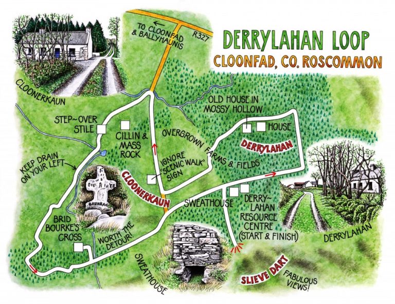
On a morning cold enough to nip the fingers, with a muted pearly light overhead and in among the conifers, I found my way to Derrylahan Resource Centre. Beside the building stood a tiny domed structure of stone – an ancient sweathouse, recently restored. You’d need to be extremely thin, or to be given a cruel kicking as incentive, to force your way inside that diminutive bee-hive hut. Once there, you’d be baked alive till the sickness was out of you, then extracted and chucked in an ice-cold stream. It was kill or cure in the old days: no namby-pambies survived around Derrylahan.
The bluish bottle-brush sprouts of the sitka spruce in Derrylahan Forest made a sombre backdrop for the tender green leaves breaking out on willows, hazels and birches all around. A robin sat on the topmost branch of a pine tree and sang as if about to burst with glee. Bog ditches glinted iridescent and thick in the strengthening sunshine. Even the darkly mysterious realm under the conifers, so redolent of Grimm fairytales, of horrid stepmothers and cannibalistic witches, seemed exorcised by spring.
Derrylahan hamlet lay among the daffodils – a neat white dwelling next to a tumbledown older neighbour in a hollow of dog’s mercury and moss. The world seemed out on its doorstep today. In nearby Cloonerkaun an old man in billycock hat and paint-splashed overalls was so busy whitewashing the stains of winter from his barn that he didn’t even look up as I went whistling by.
The advance of Derrylahan Forest had captured several townlands and their small farms whose walled fields lay wholly overgrown with stiffly rustling clumps of rushes. Beyond Cloonerkaun, though, the trees stepped back and a long and wide bog landscape unrolled northwards. Some patches bristled with the wind-bleached bones of old trees; others lay littered with coarse grey rocks studded with jewel-like blobs of gleaming white quartzite. In there somewhere, according to the map, a Mass Rock and a cillin were to be found. I scoured the dun and ochre landscape with binoculars, but never spotted them. It didn’t matter – I was contented to leave them in silent concealment, and to stroll on across the bog with lark song and wind whistle for company.
The sun released rich smells from the bog: heather, dry grasses and wet turf, myrtle, and something eucalyptus-like that I couldn’t identify. I took a detour and found Brid Bourke’s Cross, very roughly fashioned, rising from a haphazard grave of stone slabs. ‘RIP Brid Bourke, Drumbane’ was the simple inscription lettered in trickly black paint on the cross. Who was Brid Bourke? There were no clues. And where was the standing stone the map showed at the crest of Slieve Dart? I didn’t find it when I climbed there for the wind and the fifty-mile view towards Connemara. I couldn’t have cared less. The back blocks of south-west Roscommon get you right in the heart, with all their mysteries and subtle beauty. Who’d want to be anywhere else on a spring day such as this?
WAY TO GO
MAP: OS of Ireland 1:50,000 Discovery 39; downloadable map/instructions at www.discoverireland.ie/walking.
TRAVEL:
Rail (www.irishrail.ie) or bus (www.buseireann.ie) to Ballyhaunis (5 miles from Cloonfad)
Road: Follow ‘Scenic Walk Resource Centre’ sign from R327 Williamstown road, 2 miles east of Cloonfad.
WALK DIRECTIONS (purple arrow/PA waymarks): Leaving Resource Centre (OS ref M 536695), turn right along road, round sharp left bend; first left (PA) past Derrylahan hamlet for 1 mile to road at Cloonerkaun. Turn right; ignore ‘Scenic Walk’ sign on left and continue along road for ½ mile. Beyond farm on left, bear left on green track, SW, for ⅓ mile to a step-over stile (M 522700 approx – NB: waymarks briefly disappear here). Cross stile, then another lower down (522698). Keep ahead with drain on your left to road (waymarks resume). Forward for 50m; forward at left bend (PA) on bog road. Follow PAs for ½ mile to forest road (516689). Left for 1 ½ miles to Resource Centre.
Detours: (a) left at 522689 to Brid Bourke’s Cross (signed); (b) right just before Resource Centre up forest road to viewpoint on Slieve Dart.
LENGTH: 5 miles: allow 3 hours
GRADE: Easy
CONDITIONS: forest roads and tracks, bog paths. 2 step-over stiles.
DON’T MISS…!
• The rich smell of the bog in sunshine
• Brid Bourke’s Cross
• View from Slieve Dart
REFRESHMENTS: Take a picnic – several tables along walk.
ACCOMMODATION: Abbey Hotel, Galway Road, Roscommon (090-662-6240; www.abbeyhotel.ie) – very stylish and comfortable
GUIDE BOOKS/LEAFLETS: From Derrylahan Resource Centre (contact Cloonfad Scenic Walks, 087-239-6985)
INFORMATION: walking tour operators, local walks including Discover Ireland’s ‘National Loop Walks’, walking festivals throughout Ireland: www.discoverireland.ie/walking and www.coillteoutdoors.ie.
Roscommon Tourist Office: 090-66-26342; www.discoverireland.ie/west
csomerville@independent.ie